Wednesday, November 13, 2013

A very distant river!

There won't be any blogposts about the Ottawa and Rideau Rivers this month because I'm in another hemisphere (failing to recognize the constellations after dark).

Riverbus stop on the Parramatta River


Sydney Harbour Bridge from Cockatoo Island
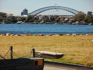
Yesterday we took river boats in both directions from Meadowbank to downtown Sydney on the Parramatta River estuary. The boats are like commuter busses, well used and frequent. Every few hundred metres there's a "bus stop" on the bank with its name (e.g. Kissing Point) visible from the river. We passed sandy beaches, sandstone cliffs and many wharfs, the wooden posts rotting away and covered with barnacles, the concrete posts less picturesque, but sturdier. Jellyfish rise and fall in the water. You can sit on the top deck of the catamarans in the sunshine and wind--hang on to your hat!--and watch the world go by. Houses on the riverbank look very desirable and are doubtless worth millions. Most have their own private fishing docks with watercraft anchored beyond them. In the distance are the Sydney skyscrapers.
Military style camping on Cockatoo Island

On our downriver ride we disembarked at Cockatoo Island, a former convict detention centre and shipbuilding yard which is undergoing a "Renaissance in every sense of the word" for the sake of the tourists. Indeed it was a fascinating place to explore, though the conditions for its poor inmates had been disturbingly harsh, and we were justifiably warned about the "aggressive seagulls" (with scarlet beaks and feet) that were nesting on the cliff face. Under the cliff was a field where tourists can camp in military tents overnight, if they wish, and on the other side of the island we found an ancient steam-powered crane, made in the 1880s.

The steam crane

Wednesday, November 6, 2013

The rocks beneath the Rideau

I had to ask, why all the little orange and yellow flags stuck in the grass in Bordeleau Park? What were all the men in fluorescent jackets doing with their measuring equipment? Why the floaters in the river and the large working boat laden with all its mysterious equipment? The answer is that a geophysical survey is underway to determine the depth of the bedrock in the riverside parks and underneath the river. They need to replace the ancient sewer that crosses the riverbed and services the districts on either side.

On the Rideau Canal website page I linked above, there's some history of the riverbed:
As the glaciers continued their retreat north, the St. Lawrence and Ottawa river valleys were exposed. The bedrock was depressed below sea level from the weight of the ice. This allowed waters of the Atlantic Ocean to fill the depressed area and mix with river waters and glacial meltwaters. This formed a brackish (partly salty) sea known as the Champlain Sea. This sea in the northern Rideau area lasted from about 12,000 BC to 11,100 BC and extended at least as far south as Rideau Ferry, perhaps to Nobles Bay of Big Rideau Lake. Evidence for this sea can be found in the sediments it deposited, including the Leda clay deposits found in the Ottawa area, many sea mollusc shells and even the bones of Beluga whales which have been found as far south as Smiths Falls. With the weight of the ice gone, the bedrock was rising, a process known as isostatic rebound. The rivers and lakes were establishing themselves.

Saturday, November 2, 2013

Controlling the flow

The website of the Ottawa River Regulation Planning Board, established in 1983 by the governments of Canada, Quebec, and Ontario to oversee the management of reservoirs of the Ottawa River basin, reports the daily water levels at various points along the Ottawa and the Gatineau Rivers, mentioning that, at present, "levels and flows on the main stem of the Ottawa River are slightly above normal for this time of the year." It also records the outflow from the Carillon dam in cubic metres per second (1700 at the last count).

The people most likely to be interested in these figures are the producers of hydro electric power in our region and the people vulnerable to floods. If there's too much or too little water flowing, one or the other of those groups is going to be affected.

Chelsea dam, Gatineau River
The dams on the Ottawa River and its tributaries are the places where the flow is controlled and the hydro electricity generated.
The combined capacity of the hydro-electric generating stations in the watershed is over 4000 MW, producing over $1 million worth of energy on a daily basis.
There are hundreds of dams and not all their effects are benefits. The Ottawa Riverkeepers list a few problems caused by dams:
  • Blocking upstream and downstream migration of fish and mussels, thereby preventing them from reaching spawning and feeding areas
  • Flooding, erosion, habitat washout
  • Scouring and armoring of the riverbed by infrequent and large releases of water
  • Rapid fluctuations in flow that do not mimic the natural flow patterns in rivers
  • Modification of water-quality parameters including water temperatures, nutrient concentration and dissolved oxygen.

November 1st by the Rideau River

It's a stormy time of year for the northern hemisphere. The wild weather and the clouds flying across the sky made me feel restless yesterday, so I went out twice across our local park to look at the river in the hope that it would calm me down.


Later in the day the park became covered in twigs, leaves and branches that had blown off the trees and the grey water was whipped into waves by the wind, gusting to >40 knots.