
Wednesday, December 28, 2011
Year's end
Sunday, December 25, 2011
Merry Christmas
After the mild December we've had, there has been some debate as to whether or not we'd get a white Christmas, but there's no doubt now that we do have one. Last night as we walked home from our friends' house (they also live near the Rideau River) the sky was clear and starry; the snow didn't begin to fall until 3 a.m. or so, but at -16ºC the river's surface was freezing rapidly and the lamps on Cummings Bridge were reflected brilliantly in its sheen. Looks and feels like Christmas, I thought.
Tuesday, December 20, 2011
Freezing over now
Back to Ottawa! The Rideau has started to acquire its icy winter crust, but open water is still predominant, with a few hooded mergansers swimming on it. Hardly any snow has fallen on the banks as yet, so the new plaques on the ground under the young memorial trees by the river path through New Edinburgh park across the river are still readable; they have touching and thought provoking messages beside the names of the people they commemorate:
... Loved forever and ever.and there is one in Italian exhorting us to celebrate the life of everyone.
... Walk in peace.
... drowned, trying to save his dog ...
aged 21, who died tragically, mourned by the whole community ...
Saturday, December 17, 2011
European rivers
 |
| Over the Neckar |
 |
| Over the Seine |
 |
| The Seufzerallee by the Neckar |
I even saw the Rhine as we crossed it at Strasbourg on the train journey from Paris to Stuttgart, where the river marks the border between France and Germany. Rhine-Donau cruise ships were docked there in readiness for next year's season.
Thursday, November 24, 2011
We haven't left yet

I shall be away too, tomorrow, but not for as long as the geese. I'm coming back to Ottawa on December 12th. The rivers I'll see during my short migration are the Thames, the Seine and perhaps the Neckar.
Wednesday, November 23, 2011
A new season starts

Friday, November 11, 2011
Another beautiful morning
I drove east along the Rockcliffe Parkway on the bluffs above the Ottawa River this morning and the view was wonderful, all the houses along the rue Jacques Cartier on the opposite bank lit up by the morning sun. The grass by the road was silvery with frost ... and so were the wing covers of our 'plane that's parked at Rockcliffe airport.
Thursday, November 10, 2011
Seeds in the wind
Not many flowers are still in bloom along the banks of the river, but the potential for next year's flowers is already there.
Dandelions are much in evidence around the time of the Ottawa Tulip Festival (in May), so much so that Kemptville in the township of North Grenville, further up the Rideau River, hosts a rival Dandelion Festival.
The pods of the milkweed plants, once empty of seeds, can serve as pretty Christmas decorations in a vase or doorway plant pot. In people's gardens, these plants are often seen as invasive nuisances, weeds that are hard to eradicate. However, the flowers of the milkweed are famous for attracting the Monarch butterflies that migrate here all the way from Mexico. I'm afraid their numbers are diminishing, so they need all the help they can get.
 |
| Dandelion seed head in November |
 |
| Dandelions by the river in May |
 |
| Milkweed seed head |
Wednesday, November 9, 2011
Whale at Smiths Falls?
The organisation called Friends of the Rideau publishes a newsletter three times a year, and its latest edition opens with an article about the geological history of the region, including the mention of whale bones found at Smiths Falls. The article is illustrated with an extraordinary "photo" and caption which I hope they don't mind my republishing here. Ken Watson obviously has a sense of humour.
An extract from the article:
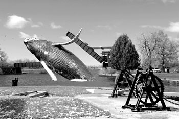 |
Humpback Whale at Smiths Fall Detached Lock The rare sight of a humpback whale breaching in the basin just above the Smiths Falls Detached Lock. This large animal has a gentle nature and is always respectful to Rideau boaters. Whale photo - NOAA, Smiths Fall Detached photo - Ken Watson |
... In 1883, gravel to be used as railway ballast was being excavated from the Welsh gravel pit, about 5 km north of Smiths Falls. Workers in the pit came across several large bones. Word of these bones came to the attention of J.W. Dawson of McGill University, a geologist who specialized in this sort of thing. He collected the bones and they were later identified as being pieces of a vertebrae and a rib of a humpback whale (Megaptera novaeangliae). Later investigators found bones of beluga whales (such as those in a gravel pit at the northern edge of the Ottawa airport), marine clams and other evidence of a moderate saltwater environment that existed in this area at the end of the last ice age.
This saltwater environment was the Champlain Sea, formed about 13,000 years ago as the glaciers continued their retreat over the depressed landscape. Waters from the Atlantic Ocean mixed with glacial melt-waters and river drainage to create a brackish sea which extended past (west and south) of Ottawa. The southern limit of this sea on the Rideau Canal was near Nobles Bay of Big Rideau Lake. And, at that time, beluga whales, and at least one humpback whale, were swimming over what is the Rideau River today. That same sea is also responsible for the deposition of the famous (or infamous) Leda clay – the unstable “quick clay” that underlies large areas near Ottawa (and some other parts of eastern Ontario)...
At the water's edge
 |
| The river's edge by daylight |
When we walk by the river in the dark, even though a full moon might be shining (that and the stars reflected in the water) we can't always see clearly what's in the shadows.
"That's not ice, is it?" said Chris the other night as we came through Bordeleau Park. Something pale, flat and thin had spread itself on the water's surface near the bank.
No, it wasn't ice (yet). It was a layer of fallen leaves.
Wednesday, November 2, 2011
A miniature river of stones
I am going to the Museum of Civilisation on the other side of the Ottawa River this morning and if I have time shall take a look outside at the Japanese "Zen Garden" ––created on a rooftop opposite the main building. This miniature landscape has a simple, peaceful look, resembling a mountain stream and its rocky banks, with pebbles representing the flow of water. (I took these photos about a month ago, so with the season's advance, the look will be different now.)


The Japanese co-designer Shunmyo Masuno has done such things in other parts of the world as well, using material found locally (here, the stones come from the Gatineau hills). You can find another picture of the Gatineau garden on his "Overseas" page (scroll down). It was designed with the theme Wakei No Niwa in mind, a reference to understanding and respect between the Japanese and Canadians. The pebbles may only be raked on ceremonial occasions by a Zen Buddhist priest. The garden was officially opened in 1995 in the presence of Prince and Princess Takamado of Japan.
Wednesday, October 26, 2011
Sun rising on the Ottawa
I'm cheating. This photo wasn't taken by me; it was linked from one of the websites I most frequently visit, the Ottawa page at The Weather Network, which incidentally is predicting a "feels like" temperature of -7º for tonight.
Posted by Gabrielle McCann, this photo was apparently taken this morning on the Hurtubise Boulevard in Gatineau, looking south across the Ottawa River. Note the leafless tree in the foreground!
Tuesday, October 25, 2011
The playground by the water's edge
 |
| End of October, 2011 |
At this time of year I feel nostalgic, remembering the visit of our then two-year-old grandson a couple of years ago. He enjoyed this corner of the park very much.

 |
| End of October, 2009 |

Sunday, October 23, 2011
Late autumn

Some of the small trees growing on the banks are covered with black berries: I think they are either chokeberries (Aronia Melanocarpa, or some kind of buckthorn.
Water levels look very low in both the Ottawa River and the Rideau at the moment with stony beaches emerging; no doubt they'll disappear again soon. The Rideau Canal was already drained of most of its water a couple of weeks ago and won't take boats through the city again for another 5 or 6 months now.
Saturday, October 22, 2011
A little red tree
 The autumn leaves haven't yet completely gone in spite of some heavy rain and winds this week. Newly planted trees can be found growing by the Rideau River these days and being small are sheltered by the larger ones, so don't lose their colour so quickly. This young maple catches my eye near our house. You can see why.
Monday, October 17, 2011
A walk for the dogs
Sunday afternoon, as we left Cathcart Street, we saw a long line of people, far more than normal, taking their dogs for a walk by the river. There must be some reason for that, I assumed, and sure enough I discover that the Cumberland Lions Club organised this event to raise money for guide dogs, or dog guides, as they prefer to call them: a stroll from the De La Salle school opposite the Chinese Embassy following the river banks back to the Rockcliffe Retirement Residence on Porter Island—more or less our usual evening walk, in fact.
Here is a map showing the route of the dog walk.
I noticed that all the dogs were on leashes on this occasion; that's not always the case, but near our house it ought to be. Undisciplined, off-leash dogs can be a hazard to people and to themselves. An over-excited dog could veer off into the traffic on King Edward Island if it's not kept under control, or in early / late winter could run onto the thin ice of the (deep, cold, rushing) river and fall through, closely followed by its owner (trying to rescue it) in some cases. Such tragedies have been known to happen.
According to this map dogs are allowed to run free in Bordeleau Park and in New Edinburgh Park across the river. The Ottawa Bylaw 2003 - 77 has a good deal to say on the subject of dogs and parks: see sections 42-48 of that document.
Thursday, October 13, 2011
Two tributaries of the Ottawa


Saturday, October 8, 2011
Aboard the Paula D.
CFUW-Ottawa's Diplomatic Hospitality Group invited diplomat families and friends to a cruise on the Ottawa River last week, on the Paula D., a river boat chartered from Paul's Boat Lines. About 130 people came along.
The water was calm and smooth on a cold but very bright October morning, the passengers feeling the chill on the top deck, although it was cosy enough on the enclosed deck below where soup and sandwiches were being served. We sailed from the Hull Marina to beyond the confluence with the Gatineau River at Pointe Gatineau before turning back, but were too busy socialising to pay very much attention to the scenery, except for the Rideau Falls on the way out, which the boat approached closely enough for us to feel the spray.
With a D.J. on board the dancing soon began to dance and that and the sunshine warmed people up. Then, introduced by the Indian High Commissioner's wife Rina Gavai who was participating in the cruise, a special entertainment was provided by Indian dancers, demonstrating a classical dance in costumes meant for a warmer climate, and bare feet, with anklets of little bells.
 |
| A Rockcliffe headland seen from on board |
 |
| View from the Paula D. |
The water was calm and smooth on a cold but very bright October morning, the passengers feeling the chill on the top deck, although it was cosy enough on the enclosed deck below where soup and sandwiches were being served. We sailed from the Hull Marina to beyond the confluence with the Gatineau River at Pointe Gatineau before turning back, but were too busy socialising to pay very much attention to the scenery, except for the Rideau Falls on the way out, which the boat approached closely enough for us to feel the spray.
With a D.J. on board the dancing soon began to dance and that and the sunshine warmed people up. Then, introduced by the Indian High Commissioner's wife Rina Gavai who was participating in the cruise, a special entertainment was provided by Indian dancers, demonstrating a classical dance in costumes meant for a warmer climate, and bare feet, with anklets of little bells.
 |
| Indian classical dancers entertain the cruise passengers |
 |
Wednesday, October 5, 2011
On an autumn evening
A calm, fine evening this evening, with the poplar trees making perfect reflections in the Rideau, the surface of the water tinged pink by the sunset. To the delight of my visitors from overseas, a beaver swam in circles, slapping its tail on the water and diving when it noticed we were there. A flock of geese took off from the lawn beside the newly named John G. Diefenbaker building. We looked for groundhogs on Maple Island but only found their holes.
Frost is forecast for tonight with the temperature probably dropping to 0º.
Frost is forecast for tonight with the temperature probably dropping to 0º.
Sunday, October 2, 2011
25 years of protest
Pulling out into Cathcart Street yesterday, I drove past a group of people standing at a trestle table that had been erected in the Bordeleau Park. On the table was a large cake decorated with a 25. That's an odd place for a birthday party, I thought, but it wasn't that exactly. It was a gathering to celebrate the anniversary of the founding of the King Edward Avenue Task Force, a pressure group that for the last quarter century (!) has been trying in vain to do something about the heavy volume of traffic rolling down this large road through our residential neighbourhood. A report of their get-together on Saturday morning made the front page of the City section of the Ottawa Citizen today.
The local politicians and councillors all claim to support the Task Force and agree that something has to be done, but very little headway is made, the sticking point being the need for an alternative to the MacDonald-Cartier interprovincial bridge, towards which King Edward Avenue leads, straight as a die, drawing heavy vehicles right through Ottawa's downtown core. And, as the article in the citizen says, drivers on their way home to Quebec race along the avenue towards the bridge at 75kph, even though the posted speed limit is 40kph. There are not enough bridges across the Ottawa, but where should the new one be built? that is the perennial question.
So far, the only candidate who has come round to our house before the provincial elections next week has been the Green Party candidate, Dave Bagler. He told me he favoured "the Canotek option" for the siting of the next bridge across the Ottawa, and also thought that the disused rail bridge (the Prince of Wales Bridge) upstream of the Chaudière Falls should be repaired and brought back into service.
I agree. All it takes is the political will to make these things happen.
 |
| The MacDonald-Cartier Bridge, from the Gatineau side |
...any discussion of building another bridge to link Ottawa with Gatineau - across Kettle Island or the Upper and Lower Duck islands have been well-discussed options - are generally met with strong opposition from those neighbourhoods ...
 |
| The old rail bridge (at the bottom of my photo), with Lemieux Island behind it |
I agree. All it takes is the political will to make these things happen.
Saturday, October 1, 2011
Red and green
 |
| Wikipedia photo of Staghorn Sumac |
The sumacs' conical fruit (aka drupes) have been red since mid-summer. As First Nations people know, or used to know, apart from their medicinal properties, these plants have numerous other potential uses:
... The leaves are rich in tannin, up to 48% has been obtained in a controlled plantation. They can be collected as they fall in the autumn and used as a brown dye or as a mordant. The bark, especially the root bark, and the fruits are also very rich in tannin. A yellow dye can be obtained from the roots. An orange dye can be obtained from the inner bark and central pith of the stem, mixed with bloodroot (Sanguinaria canadensis). A black ink can be made by boiling the leaves and the fruit. An oil is extracted from the seeds. It attains a tallow-like consistency on standing and is used to make candles. These burn brilliantly, though they emit a pungent smoke. Pipes are made from the young shoots and are used for drawing the sap of sugar maples. They are also used as flutes. The plant has an extensive root system and is planted as a windbreak screen and to prevent soil erosion.(from Plants for a Future)
Saturday, September 24, 2011
The geese are gathering
 |
| Flock of geese on the Rideau (photo taken this time last year) |
Bird strikes are a hazard for pilots at this time of year. There were many geese at Rockcliffe airport today and while Chris was flying today he heard Air Traffic Control reporting signals from skeins of geese on their radar equipment. I spotted a long line of geese flying above the airport myself, pointing this out to some people from Germany, for whom it's a novel sight.
One of the ways in which the birds navigate, it seems, is to follow the course of rivers.
The weather is still warm so we were wondering how the geese know that winter is coming closer. We assume it is the shorter days and longer nights that make them feel restless to get going. The tree tops are changing colour now as well. Do geese have colour vision?
Wednesday, September 21, 2011
Seniors and turtle eggs

The Rockcliffe's most interesting creature neighbours were the very large turtles which crawled up the riverbank to lay eggs in our gardens. We decided to protect the nests as best we could from marauders. The immense Linden trees in the patio garden came into full leaf making lovely shady spaces where we could sit and listen to the birds. The outdoor bar was opened and we were able to enjoy dining on the patio.This retirement residence is situated on Porter Island.
I see from the Library and Archives Canada website that Porter Island used to be home to the Good Shepherd Convent, also a fairly tall building for its day.
Tuesday, September 20, 2011
Ottawa to Kingston
Flying above Ottawa, as I have mentioned before, it's clear to see how the city's three rivers determine the layout of its infrastructure. In my photo below, the Gatineau River valley can just be discerned in the distance.
We are thinking of hiking the length of the Rideau River one day, a 305km trek which could take a couple of weeks at least, especially if we had a load of provisions and clothes on our backs. There is a Rideau Trail Association too that organises group walking along the trail in stages.
(My brother-in-law Phil, by the way, a keen hiker in the UK, has just published a mischievous blogpost about people who walk in groups, illustrated by one of his own drawings.)
It would be nice to sleep in comfortable beds while we're foot-slogging to Kingston and there is a choice of possible lodgings on the way, although for some of the wilder stretches they may be distributed rather far apart.
Anyway, no end of possibilities. We could cycle the length of the Rideau too, if we wished, or could rent a boat. I've heard of people who have covered the distance by canoe. Following the Cataraqui Trail, it's also possible to cycle from Ottawa to Kingston. The Cataraqui River at the southern end of the journey flows into the St. Lawrence at Kingston.
 |
| Ottawa, looking north from above the Rideau River |
We are thinking of hiking the length of the Rideau River one day, a 305km trek which could take a couple of weeks at least, especially if we had a load of provisions and clothes on our backs. There is a Rideau Trail Association too that organises group walking along the trail in stages.
(My brother-in-law Phil, by the way, a keen hiker in the UK, has just published a mischievous blogpost about people who walk in groups, illustrated by one of his own drawings.)
It would be nice to sleep in comfortable beds while we're foot-slogging to Kingston and there is a choice of possible lodgings on the way, although for some of the wilder stretches they may be distributed rather far apart.
Anyway, no end of possibilities. We could cycle the length of the Rideau too, if we wished, or could rent a boat. I've heard of people who have covered the distance by canoe. Following the Cataraqui Trail, it's also possible to cycle from Ottawa to Kingston. The Cataraqui River at the southern end of the journey flows into the St. Lawrence at Kingston.
Saturday, September 17, 2011
The romance of boats
 |
| Docks on the Ottawa River at the Rockcliffe Yacht club |
Sunday, August 28, 2011
The red river
That subject heading doesn't refer to Winnipeg's river but to ours, the Rideau! We have just got back from a walk to the Rideau Falls, compelled to go out by a glimpse through our kitchen windows of the extraordinary sky. The Ottawa Citizen has already called it "a sunset to remember."
Here is a photo taken by my husband Chris from the Minto Bridges, looking towards the northwest:

Here is a photo taken by my husband Chris from the Minto Bridges, looking towards the northwest:

To cycle beside the Ottawa

Doesn't that look appealing? (The trail, I mean, not the rattly old bike.) I had just freewheeled down to the river's edge from the Rockcliffe Parkway and had stopped to look at the views up and downstream. It was a perfect day for a bike ride.
Monday, August 22, 2011
No swimming in green slime
It has not been a good summer for Ottawa's river beaches and now they are closed for the season.
The Rideau River near our house looks unattractive for swimming at present, with the usual late summer green slime spreading across its surface. According to the biologists we shouldn't complain about this, because the visible presence of algae indicates a healthy river. Or does it? Parks Canada set up a Green Slime Monitoring Partnership (seriously!) for the Rideau River last year––here's the link to their preliminary results.
The Rideau River near our house looks unattractive for swimming at present, with the usual late summer green slime spreading across its surface. According to the biologists we shouldn't complain about this, because the visible presence of algae indicates a healthy river. Or does it? Parks Canada set up a Green Slime Monitoring Partnership (seriously!) for the Rideau River last year––here's the link to their preliminary results.
Glowing in the dark
The Lumière Festival went according to schedule in New Edinburgh last Saturday; Chris and I walked back and forth through Stanley Park for about an hour after dark, seeing the Marimba band perform, with the little girls dressed as fairies dancing to its rhythm, and the Propellor Dance by people in wheel chairs (coloured lights on their wheels) as well as able-bodied dancers. A maze of paper bag lanterns had been laid out on the baseball court. It was good, simple fun. At one point we caught sight of lights rising in the sky; a flight of balloon-lanterns had been released, a lovely and novel idea. On the river bank the usual home-made paper, glass or tin lanterns decorated trees and bushes and the tennis court fence, and floating in the river itself were strange, luminous figures.
We timed our walk home to coincide with the finale of the fireworks competition that made for more colour in the dark sky. The rain did more or less hold off, that evening.
 |
| Lumière Festival light sculptures |
 |
| Swan lanterns, and their reflections |
We timed our walk home to coincide with the finale of the fireworks competition that made for more colour in the dark sky. The rain did more or less hold off, that evening.
 |
| More fireworks beyond the Minto Bridges |
Sunday, August 14, 2011
Lumière lanterns coming soon
 |
| Dark cloud over the Minto Bridges |
On previous years this has been quite magical, very atmospheric and cleverly put together; the children in particular love this occasion. However, last year's lantern festival, sad to say, was a wash out, the delicate lanterns lashed with rain in a cold wind. It is raining heavily as I write this and dark clouds have been hanging around in the afternoons and evenings, but let's hope for better luck with the weather this time round. A large number of local artists and performers have been engaged to entertain the crowds in the dark next Saturday. Good luck to them all!
Lighting up the sky
Walking home from New Edinburgh across the Minto Bridges last night, we had the Saturday night fireworks on our right, cloud-to-cloud sheet lightning in the distance on our left (and in the sky behind us), and the full moon above, reflected in the river. Visual overload! We didn't know which way to look.
Friday, August 12, 2011
Clouds over the two rivers
 |
| Getting a flight briefing |
 |
| Rising cloud seen from Montmagny |
Durant l'hiver, l'île est uniquement accessible par avion. Information amusante : les enfants de l'île aux Grues doivent se rendre à l'école à Montmagny par avion car le traversier ne peut opérer qu'à certaines heures à cause des marées et cette restriction ne permet pas de synchroniser le traversier avec les heures de classe!
 |
| Orographic cloud north of the St. Lawrence |
 |
| Layers of cloud above the St. Lawrence, east of Quebec City |
 |
| Edge of the storm near Quebec |
 |
| Better weather ahead |
 |
| Approaching Rockland over the Ottawa River |
Monday, August 8, 2011
The Maritime Museum at L'Islet-sur-mer
 |
| Distant thunderstorm over the St. Lawrence |
 |
| Chris going into the museum |
The ship that Bernier eventually acquired from Germany, originally named the Gauss, renamed L'Arctic, was his vessel of choice and he manned it with a crew of sailors who were nearly all from L'Islet-sur-mer themselves––what loyalty they must have felt for one another! His ambition was to reach the North Pole; though he never made it quite to the Pole, he was honoured for his accomplishments, having led 11 expeditions to the far north where the Inuit still remember and respect him. He died at the age of 82 at L'Islet, having made a journey to Rome the previous year, to visit the Pope.
More about Bernier and his Arctic expeditions here.
There were several other exhibitions at the museum, including one about Sea Monsters, and I toured the Chalouperie on the ground floor, learning some French and English vocabulary which I note here for future reference:
chaloupe = beach boat
 |
| On the deck of the Ernest Lapointe |
chaloupe à glace = ice boat (for the seal hunt)
voilier = sloop (although perhaps they meant skiff)
drosseuse = duck boat (used locally for hunting snow geese during the migration season)
Outside the museum our admission tickets allowed us to board the icebreaker Ernest Lapointe, a steam ship used by the Canadian Coast Guard between 1940 and 1978. We thoroughly enjoyed peering into the cabins etc and imagining life on this stylish vessel which sometimes used to accommodate VIP land-lubbers, as well as its regular crew. Had we wished, we could also have had a guided tour (in French) on board the HMCS Bras d'Or 400 hydrofoil that's kept high and dry in the museum park, but we'll leave that until another occasion. At one time this was the fastest unarmed warship in the world, but for political reasons she never came into service. The Canadian hydrofoil project was cancelled in the 1970s.
After enjoying this museum very much we meandered back towards Montmagny through the riverside villages and found Bed and Breakfast at a gîte on the Route du Souvenir in Cap St. Ignace, a place I thoroughly recommend for its cleanliness, for its attractiveness inside and out and for its value for money, not to mention the superb breakfast we were served next morning. It's called the Chocoporto, a restored farmhouse dating back to the 17th century. Incidentally the family to whom this old house had belonged were also called Bernier.
The Sunday cycle track
If we want to go to the Rockcliffe Flying Club on Sunday mornings in the summer we are stopped at a barrier where the Rockcliffe Parkway is closed to normal traffic. Chris winds down his window to say to the people manning the barrier, "To the flying club, very slowly, with both lights flashing?" and they smile and let us through.
The reason for this slight inconvenience is a very good one: the city allows cyclists and inline skaters dedicated access to the smooth surface of the scenic parkways for this four-hour period once a week (until September 4th, this year) so that they can enjoy speeding along without the need to worry about oncoming motor vehicles. Alcatel-Lucent have sponsored the initiative; good for them!
Ottawa apparently has the highest per capita population of cyclists in Canada.
Personally, when we're using our bikes, we prefer the route that takes us down to the unsurfaced trail right beside the Ottawa River, rather than along the top of the bluffs. The views up, down and across the river are exhilarating, the trail is nearly always in the shade and it continues from the old boathouse (belonging to the Ottawa New Edinburgh Club) all the way to Orleans.
The Ottawa River Pathway on the western side of the city is worth exploring too, whatever your self-propelled means of transport.
 |
| Cycle paths in Ottawa-Gatineau |
Subscribe to:
Posts (Atom)